
Can digital twins become the future of urban planning?
Digital twins, as 3D virtual replicas of the physical world, are increasingly being used by cities for planning rehearsals. Boston has been building a city model since 2015, Chattanooga uses real-time data to optimize traffic signals, and cities like New York and Las Vegas focus on building decarbonization. However, data maintenance, privacy, and cost remain major obstacles.
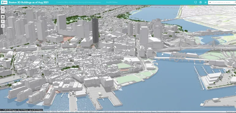
Like any city, Boston is always changing: old buildings are demolished, new ones rise, public transit winds through, and schools, grocery stores, and even trees dot the landscape. For years, the city wanted to integrate these elements into a three-dimensional digital model to simulate planning decisions before implementing them in the real world. This model was completed in 2015 and opened to the public three years later.
This digital twin covers not only the current landscape of buildings, transit, trees, sunlight and shadows, and points of interest, but also proposed and ongoing projects, serving as an archive of Boston's urban changes. Carolyn Bennett, deputy director of geographic information systems (GIS) at the Boston Planning & Development Agency, said, "It's a living, dynamic content that includes historical archives, current conditions, and the future, covering nearly the full spectrum, which greatly benefits the agency and the entire city of Boston."
A digital twin is a three-dimensional virtual replica of a specific system, place, or object, enabling cities and property owners to test changes before implementing them in the real world. From Los Angeles to coastal Texas, more cities are using this technology to study the impacts of development, transportation, climate change, and many other scenarios facing urban areas.
Ankit Srivastava, associate professor of mechanical and aerospace engineering at the Illinois Institute of Technology, noted, "You can simulate the effects of decisions before making actual changes to a real object—here, a city or campus. This makes decisions more data-driven and less costly because you can try many possibilities."
However, keeping digital twins up to date and helping cities grow requires dedicated time and effort.
Capturing the full scope of a city in the digital realm
Bennett explained that since 2005, Boston has been exploring how to integrate the vast amounts of data it has accumulated—including geospatial information on water and sewer systems, transit, and tax parcels—into a three-dimensional model. Today, Boston's digital twin has integrated this data. The city can use it to assess the impacts of development proposals on community housing, zoning, and parking. Planners can also overlay urban heat island data from other sources onto the model to visualize temperature distributions related to buildings, impervious surfaces, and tree canopy.
Bennett said, "This allows us to better visualize our work as planners. We plan in three dimensions; we are not a two-dimensional agency. We observe the world as it exists, so we must view it from a three-dimensional perspective."
Chattanooga, Tennessee, has also found digital twins to be an effective tool for integrating collected data. Jibo Sanyal, who leads the Computational Urban Sciences group at Oak Ridge National Laboratory, asked, "Can we bring all this real-time data into a common ecosystem to clearly understand what's happening?" Researchers from Oak Ridge and the National Renewable Energy Laboratory partnered with Chattanooga to build a digital twin that helps predict and alleviate traffic congestion, with Sanyal serving as the project's technical and strategy lead.
Chattanooga's digital twin aggregates information from 500 different sources, such as traffic cameras, 911 data, radar detectors, and weather stations. Sanyal said that traffic congestion experiments in this virtual environment showed traffic flow could improve by up to 30%, leading to greater energy efficiency. Researchers used these experimental results to implement adjustments in the real world. For example, traffic planners typically collect data during morning and evening peak hours, but when researchers ran digital twin experiments on Shallowford Road in Chattanooga, they found that over 90% of vehicles during the midday peak were stopped by red lights. In reality, researchers recalculated the timing of traffic signals along Shallowford Road to reduce congestion, and now they can change signal patterns every four minutes based on traffic conditions.
Chattanooga has one of the busiest freight corridors in the nation, and the digital twin also supports long-term decisions. For instance, the city wanted to know which times of day would be suitable for allowing drivers to use the shoulder as a travel lane. Sanyal said using the digital twin for such assessments reduces costs. He said, "Many studies stop after publishing a nice paper, and although the papers are often compelling, opportunities for practical application often don't exist. Chattanooga is great—they really brought us in to jointly adjust traffic light settings, fine-tune as needed, and conduct experiments in the real world. Then we observe before-and-after changes to determine what improvements were made." Although researchers currently control signals on only one corridor, Sanyal expects to control about 100 signals within a year, covering downtown Chattanooga and other high-traffic areas.
The buildings that make up a city
Digital twins can also help cities and property owners reduce energy consumption. Cities account for about 75% of global greenhouse gas emissions. To reduce pollution, cities such as New York, Boston, and Washington, D.C., have set future goals of net-zero carbon emissions for buildings. But decarbonizing buildings requires analyzing and implementing energy management systems and renewable energy strategies, as well as purchasing carbon offsets. Cityzenith is a company focused on developing urban digital twins to help with this. Its CEO, Michael Jansen, said models can start with just two to five buildings, with property owners entering data through templates, and the resulting digital twin can run optimization simulations based on factors such as building age, condition, and use, with the goal of creating more energy-efficient buildings and even cities. Las Vegas and New York City have already adopted the technology, and Phoenix and other U.S. and European cities are expected to follow. Jansen said Cityzenith plans to donate the technology to a total of 10 cities by Christmas this year, reaching 100 cities by 2024.
Obstacles to digital twins
Jansen noted that one of the main obstacles to implementing digital twins is ensuring the data needed to build the model is complete. "A digital twin is not bought," he said. "It is built." Mohammad Heidarinejad, assistant professor of architectural engineering at the Illinois Institute of Technology, said that since large cities already have vast amounts of data, he expects more cities to adopt digital twins, adding that within five to ten years these models could expand to more small and medium-sized cities. But cities and property owners will face many challenges. Heidarinejad said capturing reality with drones or scanning requires significant storage space, and digital twins must evolve as the real world changes (Boston updates its model twice a year). Srivastava suggested that one way to update digital twins is through crowdsourced data, including photos people take and agree to contribute of the city. He envisions a central system analyzing these photos and their GPS coordinates to automatically update the digital twin.
The data contained in digital twins can raise privacy concerns. If people can access the information behind the model, so can hackers. Srivastava said cities must decide how much detail to capture in a digital twin and which elements to make public, especially as global data volumes continue to grow. He said, "The real world will become increasingly virtual, simply because obtaining data becomes much easier. I think future cities will take advantage of this." This may require investment from cities. Bennett said Boston has a 3D data analyst whose primary responsibility is maintaining the city's digital twin. She said, "Cities must remain committed to this because it is living data that needs continuous updates and maintenance. This is challenging because if the model becomes too outdated, people won't want to use it."
Oak Ridge National Laboratory's Sanyal said staffing and IT overhead can be difficult for cities to afford. After all, cities want to use taxpayer money wisely, so they tend to favor proven technologies. The digital twin work Oak Ridge conducted with Chattanooga is designed to help address this issue. Oak Ridge focuses on solutions that can be scaled to other cities, so Sanyal hopes companies will license the national laboratory's technology. Nevertheless, digital twins are just one tool for cities and property owners to plan for the future, and their value depends largely on the data available. Sanyal said, "Because it is highly data-dependent, it is crucial to carefully choose the data used for decision-making. Ultimately, a digital twin is a tool, and large-scale planning decisions are usually made by humans."